More Info
KPOP Image Download
  • Top University
  • Top Anime
  • Home Design
  • Top Legend


  1. ENSIKLOPEDIA
  2. Berkas:Poland adm location map.svg - Wikipedia bahasa Indonesia, ensiklopedia bebas
Berkas:Poland adm location map.svg - Wikipedia bahasa Indonesia, ensiklopedia bebas

Berkas:Poland adm location map.svg
Konten halaman tidak didukung dalam bahasa lain.
  • Berkas
  • Pembicaraan
  • Baca
  • Lihat di Wikimedia Commons
Perkakas
Tindakan
  • Baca
  • Lihat di Wikimedia Commons
Umum
  • Pranala balik
  • Versi cetak
  • Informasi halaman
  • Lihat URL pendek
  • Unduh kode QR
Dalam proyek lain
Tampilan
Dari Wikipedia bahasa Indonesia, ensiklopedia bebas
  • Berkas
  • Riwayat berkas
  • Penggunaan berkas
  • Penggunaan berkas global
  • Metadata
Berkas:Poland adm location map.svg
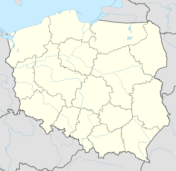
Ukuran pratayang PNG ini dari berkas SVG ini: 617 × 600 piksel Resolusi lainnya: 247 × 240 piksel | 494 × 480 piksel | 790 × 768 piksel | 1.053 × 1.024 piksel | 2.107 × 2.048 piksel | 861 × 837 piksel.

Ukuran asli (Berkas SVG, secara nominal 861 × 837 piksel, besar berkas: 340 KB)

Berkas ini berasal dari Wikimedia Commons dan mungkin digunakan oleh proyek-proyek lain. Deskripsi dari halaman deskripsinya ditunjukkan di bawah ini.

Ringkasan

DeskripsiPoland adm location map.svg
Deutsch: Positionskarte von Polen
English: Location map of Poland

Equirectangular projection, vertical stretching 160 %
Border coordinates

55.2
13.8←↕→24.5
48.7
 Info This map is part of a series of location maps with unified standards: SVG as file format, standardised colours and name scheme. The boundaries on these maps always show the de facto situation and do not imply any endorsement or acceptance. In case of changes of the shown area the file is updated. The old version will be uploaded as a new file and thus is still available.
Tanggal 10 September 2014
Sumber

Own work using:

  • United States National Imagery and Mapping Agency data
  • World Data Base II data
Pembuat NordNordWest
SVG genesis
InfoField
 
The SVG code is valid.
 
Gambar vektor ini dibuat menggunakan Adobe Illustrator
Kartenwerkstatt
This SVG map has been made or improved in the German Kartenwerkstatt (Map Lab). You can propose maps to improve as well.

azərbaycanca ∙ čeština ∙ Deutsch ∙ Deutsch (Sie-Form) ∙ English ∙ español ∙ français ∙ italiano ∙ latviešu ∙ magyar ∙ Nederlands ∙ Plattdüütsch ∙ polski ∙ português ∙ română ∙ sicilianu ∙ slovenščina ∙ suomi ∙ oʻzbekcha / ўзбекча/ ∙ македонски ∙ русский ∙ ქართული ∙ հայերեն ∙ বাংলা ∙ ไทย ∙ +/−

Lisensi

Usage of this file with:

Map: NordNordWest, Licence: Creative Commons by-sa-3.0 de

explanatory notes: Legally binding is only the full legalcode. For a free usage I recommend to respect the following licence conditions:
1. Provide my name as given above: NordNordWest,
2. a copy of, or the URI for, the applicable license: https://creativecommons.org/licenses/by-sa/3.0/de/legalcode,
3. the title of the work,
4. in the case of an adaptation, a credit identifying the use of the work in the adaptation.
This license and the rights granted hereunder will terminate automatically upon any breach by you of the terms of this license. Any of the above conditions can be waived if you get permission from the copyright holder. If you have questions or wish differing conditions, please contact me through nnwest@t-online.de or my discussion page

w:id:Creative Commons
atribusi berbagi serupa
Berkas ini dilisensikan di bawah lisensi Creative Commons Atribusi-Berbagi Serupa 3.0 Jerman.
Atribusi: Karte: NordNordWest, Lizenz: Creative Commons by-sa-3.0 de
Anda diizinkan:
  • untuk berbagi – untuk menyalin, mendistribusikan dan memindahkan karya ini
  • untuk menggubah – untuk mengadaptasi karya ini
Berdasarkan ketentuan berikut:
  • atribusi – Anda harus mencantumkan atribusi yang sesuai, memberikan pranala ke lisensi, dan memberi tahu bila ada perubahan. Anda dapat melakukannya melalui cara yang Anda inginkan, namun tidak menyatakan bahwa pemberi lisensi mendukung Anda atau penggunaan Anda.
  • berbagi serupa – Apabila Anda menggubah, mengubah, atau membuat turunan dari materi ini, Anda harus menyebarluaskan kontribusi Anda di bawah lisensi yang sama atau kompatibel dengan lisensi pada materi asli.
https://creativecommons.org/licenses/by-sa/3.0/de/deed.enCC BY-SA 3.0 deCreative Commons Attribution-Share Alike 3.0 detruetrue

Captions

Add a one-line explanation of what this file represents
Position map of Poland
מיקום במפת פולין
Positionskarte von Polen
Mappa di posizione della Polonia
Carte de position de la Pologne
폴란드의 위치 지도
Адміністративна карта Польщі
Mapa administracyjna Polski
Карта положения Польша

Items portrayed in this file

menggambarkan

Polandia

status hak cipta

berhak cipta

lisensi

Creative Commons Attribution-ShareAlike 3.0 Germany Inggris

sejak

10 September 2014

tipe media

image/svg+xml

Riwayat berkas

Klik pada tanggal/waktu untuk melihat berkas ini pada saat tersebut.

Tanggal/WaktuMiniaturDimensiPenggunaKomentar
terkini10 September 2014 19.14Miniatur versi sejak 10 September 2014 19.14861 × 837 (340 KB)NordNordWest== {{int:filedesc}} == {{Information |Description= {{de|1=Positionskarte von Polen}} {{en|1=Location map of Poland}} {{Location map series N |top=55.2 |bottom=48.7 |left=13.8 |right=24.5 }} |Source={{Own using}} * United States National Imagery and Map...

Penggunaan berkas

91 halaman berikut menggunakan berkas ini:

  • Aleksandrów Łódzki
  • Alwernia
  • Andrychów
  • Augustów
  • Bandar Udara Chopin Warsawa
  • Bandar Udara Internasional Katowice
  • Bandar Udara Krywlany
  • Bandar Udara Toruń
  • Baranów Sandomierski
  • Barcin
  • Bardo, Polandia
  • Barwice
  • Basilika Bunda Maria di Licheń
  • Basilika Maria Diangkat ke Surga, Krzeszów
  • Basilika Maria Mengunjungi Elisabet, Radków
  • Basilika Santa Jadwiga dan Santo Bartolomeus, Trzebnica
  • Bełchatów
  • Biara Jasna Góra
  • Biara Krzeszów
  • Biara Mogiła
  • Biała Piska
  • Białogard
  • Biały Bór
  • Bierutów
  • Bieruń
  • Brzesko
  • Brzezinka
  • Brześć Kujawski
  • Brzozów
  • Bukowno
  • Byczyna
  • Bystrzyca Kłodzka
  • Bytom Odrzański
  • Chełmek
  • Chełmno
  • Chmielnik
  • Chęciny
  • Ciechanów
  • Daftar Situs Warisan Dunia di Eropa
  • Daftar klub sepak bola divisi tertinggi di negara anggota UEFA
  • Ekstraklasa
  • Gereja Kolegiat Salib Suci dan Santo Bartolomeus, Wrocław
  • Grodzisk Mazowiecki
  • Gutowo Małe
  • Huta Piekarska
  • Istana Wilanów
  • Izbica Kujawska
  • Kamp konsentrasi Monowitz
  • Kamp pemusnahan Belzec
  • Kamp pemusnahan Sobibor
  • Katedral Gorzów Wielkopolski
  • Katedral Katolik Yunani Ukraina Wrocław
  • Katedral Pelplin
  • Katedral Toruń
  • Kejuaraan Dunia Bola Voli Putra FIVB 2014
  • Kejuaraan Eropa UEFA 2012
  • Kejuaraan U-21 Eropa UEFA 2017
  • Klątwy
  • Kochoń
  • Kock
  • Kościan
  • Krzywiń
  • Kutyski
  • Lipniki, Garwolin County
  • Lębork
  • Małujowice
  • Międzybrodzie Bialskie
  • Museum Nasional, Warsawa
  • Mysłowice
  • Nisko
  • Nuna, Polandia
  • Oświęcim
  • Pertempuran Raszyn (1809)
  • Piala Dunia U-20 FIFA 2019
  • Plot 20 Juli
  • Pocześle
  • Potachy
  • Raszyn
  • Resko
  • Rożki, Provinsi Mazowsze
  • Sianno
  • Skwierzyna
  • Stare Chojny
  • Szklarska Poręba
  • Trutnowo, Kuyavian-Pomeranian Voivodeship
  • Trutnowo, Warmian-Masurian Voivodeship
  • Wielbark, Provinsi Warmia-Masuria
  • Wołów
  • Wrocław
  • Zosin, Powiat Łęczna
  • Templat:Location map Polandia

Penggunaan berkas global

Wiki lain berikut menggunakan berkas ini:

  • Penggunaan pada ab.wikipedia.org
    • Амодуль:Location map/data/Poland
    • Амодуль:Location map/data/Poland/doc
  • Penggunaan pada af.wikipedia.org
    • Trawniki
    • Babsk
    • Stara Rawa
    • Raducz
    • Jeruzal
    • Dziecinów (Otwocki-distrik)
    • Trzeszczyna
    • Nowy Dwór Królewski
    • Siepietnica
    • Papowo Biskupie
    • Dubielno
    • Falęcin
    • Firlus
    • Folgowo
    • Jeleniec
    • Kucborek
    • Niemczyk
    • Staw
    • Storlus
    • Wrocławki
    • Zegartowice
    • Żygląd
    • Stębark
    • Kasteel van Malbork
    • Rowy, Pommere
    • Wielopole
    • Tenczynek
    • Rudno
    • Nowa Góra
    • Rudawa
    • Młoszowa
    • Ostrężnica
    • Nawojowa Góra
    • Europese Sokkerkampioenskap 2012
    • Jadowniki
    • Sjabloon:Liggingkaart Pole
    • Ząbrowo (Woiwodskap Pommere)
    • Auschwitz-konsentrasiekamp
    • Trojany
    • Bochotnica
    • Stary Dwór
    • Hajnówka
    • Truso
    • Piotrowice (Otwocki-distrik)
    • Bielawa
    • Puńsk
    • Dębica
    • Wisłok

Lihat lebih banyak penggunaan global dari berkas ini.

Metadata

Berkas ini mengandung informasi tambahan yang mungkin ditambahkan oleh kamera digital atau pemindai yang digunakan untuk membuat atau mendigitalisasi berkas. Jika berkas ini telah mengalami modifikasi, rincian yang ada mungkin tidak secara penuh merefleksikan informasi dari gambar yang sudah dimodifikasi ini.

Lebar861.39px
Tinggi837.239px
Diperoleh dari "https://id.wikipedia.org/wiki/Berkas:Poland_adm_location_map.svg"

Best Rank
More Recommended Articles