More Info
KPOP Image Download
  • Top University
  • Top Anime
  • Home Design
  • Top Legend


  1. ENSIKLOPEDIA
  2. Berkas:World of Ptolemy as shown by Johannes de Armsshein - Ulm 1482.png - Wikipedia bahasa Indonesia, ensiklopedia bebas
Berkas:World of Ptolemy as shown by Johannes de Armsshein - Ulm 1482.png - Wikipedia bahasa Indonesia, ensiklopedia bebas

Berkas:World of Ptolemy as shown by Johannes de Armsshein - Ulm 1482.png

Konten halaman tidak didukung dalam bahasa lain.
  • Berkas
  • Pembicaraan
  • Baca
  • Lihat di Wikimedia Commons
Perkakas
Tindakan
  • Baca
  • Lihat di Wikimedia Commons
Umum
  • Pranala balik
  • Versi cetak
  • Informasi halaman
  • Lihat URL pendek
  • Unduh kode QR
Dalam proyek lain
Tampilan
Dari Wikipedia bahasa Indonesia, ensiklopedia bebas
  • Berkas
  • Riwayat berkas
  • Penggunaan berkas
  • Penggunaan berkas global
Berkas:World of Ptolemy as shown by Johannes de Armsshein - Ulm 1482.png
Ukuran pratayang ini: 800 × 582 piksel. Resolusi lainnya: 320 × 233 piksel | 640 × 465 piksel | 1.024 × 744 piksel | 1.168 × 849 piksel.

Ukuran asli (1.168 × 849 piksel, ukuran berkas: 2,97 MB, tipe MIME: image/png)

Berkas ini berasal dari Wikimedia Commons dan mungkin digunakan oleh proyek-proyek lain. Deskripsi dari halaman deskripsinya ditunjukkan di bawah ini.

Seniman/Pembuat
Lord Nicolas the German (Donnus Nicholas Germanus), cartographer
Johann the Blockcutter of Armsheim (Johannes Schnitzer or Johannes de Armsheim), engraver
Pembuat
Ptolemy
Jacobus Angelus, translator
Deskripsi
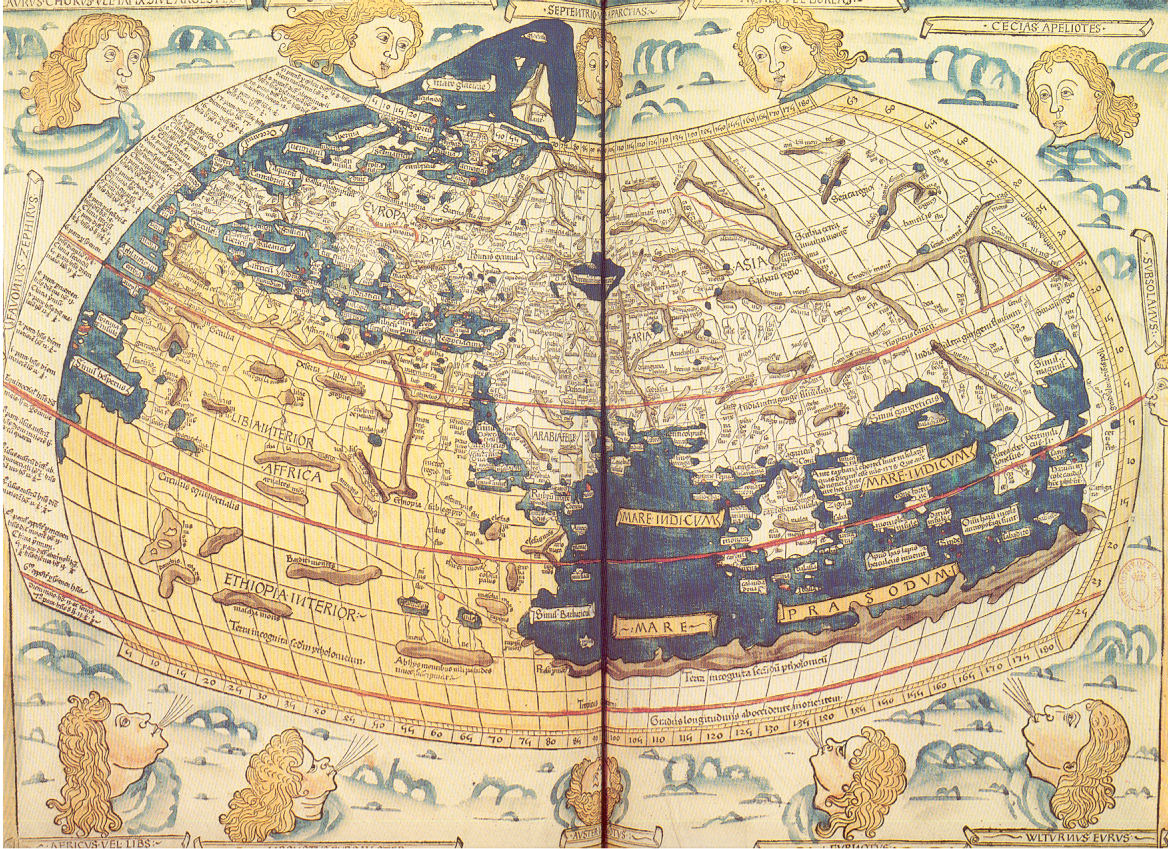
English: The world map from a 1482 edition of Nicolaus Germanus's emendations to Jacobus Angelus's 1406 Latin translation of Maximus Planudes's late-13th century rediscovered Greek manuscripts of Ptolemy's 2nd-century Geography.
Français : On ne possède aucune carte de Ptolémée. Celle que nous reproduisons a été gravée sur bois à Ulm en 1482 par Johannes de Armsheim dont le nom est porté dans la marge supérieure.
Conçue comme une sphère, la Terre comporte les trois continents de l'Antiquité : Europe, Asie et Afrique, environ le tiers du monde aujourd'hui connu.
Les vents représentés par des têtes aux cheveux blonds soufflent sur la Terre.
Sumber/Fotografer Extrait du périscope "La cartographie", éditions PEMF - CANNES
Izin
(Menggunakan kembali berkas ini)

Ce document vous est offet par les Publications de l'Ecole moderne française, BP109-06322 CANNES-LA BOCCA CEDEX (sentence refering to the source document itself)

Public domainPublic domainfalsefalse
Public domain

This work is in the public domain in its country of origin and other countries and areas where the copyright term is the author's life plus 70 years or fewer.


You must also include a United States public domain tag to indicate why this work is in the public domain in the United States.
 Note that a few countries have copyright terms longer than 70 years: Mexico has 100 years, Jamaica has 95 years, Colombia has 80 years, and Guatemala and Samoa have 75 years. This image may not be in the public domain in these countries, which moreover do not implement the rule of the shorter term. Honduras has a general copyright term of 75 years, but it does implement the rule of the shorter term. Copyright may extend on works created by French who died for France in World War II (more information), Russians who served in the Eastern Front of World War II (known as the Great Patriotic War in Russia) and posthumously rehabilitated victims of Soviet repressions (more information).
Berkas ini telah diidentifikasi bebas dari pembatasan menurut hukum hak cipta termasuk semua hak terkait dan relevan.
https://creativecommons.org/publicdomain/mark/1.0/PDMCreative Commons Public Domain Mark 1.0falsefalse
Versi lainnya

Riwayat berkas

Klik pada tanggal/waktu untuk melihat berkas ini pada saat tersebut.

Tanggal/WaktuMiniaturDimensiPenggunaKomentar
terkini8 Juli 2006 14.22Miniatur versi sejak 8 Juli 2006 14.221.168 × 849 (2,97 MB)Holycharly~commonswiki{{Information |Description= Historical Map of the Old World, as en:Ptolemy knew it.<br/> Backcover description from the scanned document :<br/> :''On ne possède aucune carte de Ptolémée. Celle que nous reproduisons a été gravée sur bois à Ulm

Penggunaan berkas

Halaman berikut menggunakan berkas ini:

  • Klaudius Ptolemaeus

Penggunaan berkas global

Wiki lain berikut menggunakan berkas ini:

  • Penggunaan pada ast.wikipedia.org
    • Toloméu
    • Climatoloxía
  • Penggunaan pada bn.wikipedia.org
    • ১৫০-এর দশক
  • Penggunaan pada es.wikipedia.org
    • Climatología
    • Claudio Ptolomeo
    • Clima zonal
  • Penggunaan pada fr.wikipedia.org
    • Années 150
  • Penggunaan pada fr.wikiversity.org
    • Représentations et cartes du monde/Histoire de la carte
  • Penggunaan pada fy.wikipedia.org
    • Ptoleméus
  • Penggunaan pada ga.wikipedia.org
    • Clíomeolaíocht
  • Penggunaan pada ja.wikipedia.org
    • 初期の世界地図
  • Penggunaan pada nds-nl.wikipedia.org
    • Ptolemaeus
  • Penggunaan pada nl.wikipedia.org
    • Vasco da Gama
    • Claudius Ptolemaeus
  • Penggunaan pada uk.wikipedia.org
    • 150-ті
Diperoleh dari "https://id.wikipedia.org/wiki/Berkas:World_of_Ptolemy_as_shown_by_Johannes_de_Armsshein_-_Ulm_1482.png"

Best Rank
More Recommended Articles