Ma'alul
Ma'alul
معلول Ma'lul, Maalul, Maaloul, Mahlul | |
|---|---|
 Sebuah Gereja Katolik Ma'alul pada Juli 2010 | |
| Etimologi: dari nama personal[1] | |
 Ma'alul Lokasi di Mandat Palestina | |
| Koordinat: 32°41′44″N 35°14′22″E / 32.69556°N 35.23944°E | |
| Grid Palestina | 172/233 |
| Entitas geopolitik | Mandat Palestina |
| Subdistrik | Nazareth |
| Tanggal pengosongan | 15 Juli 1948[4] |
| Luas | |
| • Total | 4,698 dunams (4,698 km2 or 1,814 sq mi) |
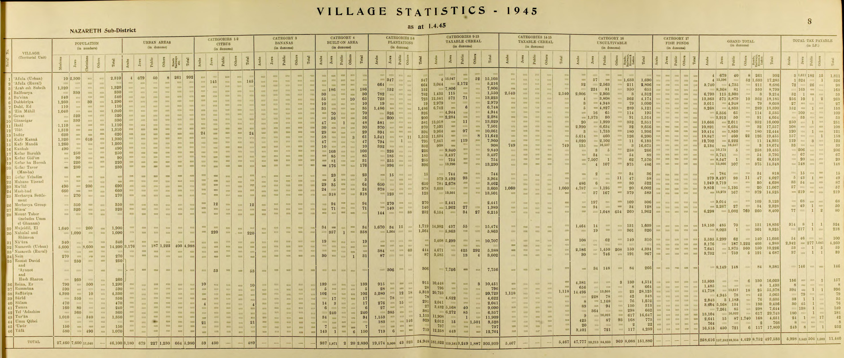
| Populasi (1945) | |
| • Total | 690[2][3] |
| Sebab pengosongan | Serangan militer oleh pasukan Yishuv |
| Wilayah saat ini | Migdal HaEmek, Kfar HaHoresh, Timrat,[5][6] dan sebuah pangkalan militer Israel |
Ma'alul (bahasa Arab: معلول) adalah sebuah desa yang utamanya terdiri dari Kristen Palestina. Desa tersebut dikosongkan dan dihancurkan oleh Israel pada Perang Arab-Israel 1948. Berjarak enam kilometer dari barat kota Nazareth,[7] sebagian besar penduduknya menjadi pengungsi yang diusir secara internal usai mengungsi ke Nazareth[8] dan kota tetangganya Yafa an-Naseriyye.[9]
Referensi
- ^ Palmer, 1881, p. 113
- ^ a b Government of Palestine, Department of Statistics. Village Statistics, April, 1945. Quoted in Hadawi, 1970, p. 62
- ^ Department of Statistics, 1945, p. 8
- ^ Morris, 2004, p. xvii, village #138. Also gives cause of depopulation.
- ^ Morris, 2004, p. xx, settlement #12.
- ^ Khalidi, 1992, p. 347
- ^ Ma'lul, Palestine Remembered, diakses tanggal 2008-03-31
- ^ Rabinowitz, 1997, p. 27
- ^ Nihad Bokae'e (February 2003), Palestinian Internally Displaced Persons inside Israel:Challenging the Solid Structures (PDF), Badil, diarsipkan dari asli (PDF) tanggal June 14, 2007
Daftar pustaka
- Barron, J. B., ed. (1923). Palestine: Report and General Abstracts of the Census of 1922. Government of Palestine.
- Conder, C.R.; Kitchener, H.H. (1881). The Survey of Western Palestine: Memoirs of the Topography, Orography, Hydrography, and Archaeology. Vol. 1. London: Committee of the Palestine Exploration Fund.
- Department of Statistics (1945). Village Statistics, April, 1945. Government of Palestine.
- De Haas, J. (1934). History of Palestine - The Last Two Thousand Years. Macmillan.
- Guérin, V. (1880). Description Géographique Historique et Archéologique de la Palestine (dalam bahasa French). Vol. 3: Galilee, pt. 1. Paris: L'Imprimerie Nationale. Pemeliharaan CS1: Bahasa yang tidak diketahui (link)
- Hadawi, S. (1970). Village Statistics of 1945: A Classification of Land and Area ownership in Palestine. Palestine Liberation Organization Research Center.
- Hütteroth, Wolf-Dieter; Abdulfattah, Kamal (1977). Historical Geography of Palestine, Transjordan and Southern Syria in the Late 16th Century. Erlanger Geographische Arbeiten, Sonderband 5. Erlangen, Germany: Vorstand der Fränkischen Geographischen Gesellschaft. ISBN 3-920405-41-2.
- Karmon, Y. (1960). "An Analysis of Jacotin's Map of Palestine" (PDF). Israel Exploration Journal. 10 (3, 4): 155–173, 244–253. Diarsipkan dari asli (PDF) tanggal 2019-12-22. Diakses tanggal 2020-07-26.
- Keil, C.F. (1865). Joshua, Judges, Ruth, tr. by J. Martin. Oxford University.
- Khalidi, W. (1992). All That Remains: The Palestinian Villages Occupied and Depopulated by Israel in 1948. Washington D.C.: Institute for Palestine Studies. ISBN 0-88728-224-5.
- Mills, E., ed. (1932). Census of Palestine 1931. Population of Villages, Towns and Administrative Areas. Jerusalem: Government of Palestine.
- Morris, B. (2004). The Birth of the Palestinian Refugee Problem Revisited. Cambridge University Press. ISBN 978-0-521-00967-6.
- Palmer, E. H. (1881). The Survey of Western Palestine: Arabic and English Name Lists Collected During the Survey by Lieutenants Conder and Kitchener, R. E. Transliterated and Explained by E.H. Palmer. Committee of the Palestine Exploration Fund.
- Pappé, I. (2006). The Ethnic Cleansing of Palestine. London and New York: Oneworld. ISBN 1-85168-467-0.
- Rabinowitz, Dan (1997). Overlooking Nazareth: The Ethnography of Exclusion in Galilee. Cambridge University Press. ISBN 0-521-56495-6.
- Rhode, H. (1979). Administration and Population of the Sancak of Safed in the Sixteenth Century. Columbia University. Diarsipkan dari asli tanggal 2019-04-20. Diakses tanggal 2020-07-26.
- Schumacher, G. (1888). "Population list of the Liwa of Akka". Quarterly statement - Palestine Exploration Fund. 20: 169–191.
- Schwarz, Joseph (1850). A Descriptive Geography and Brief Historical Sketch of Palestine. Translated by Isaac Leeser. Macmillan.
Pranala luar
- Welcome To Ma'lul
- Ma'alul, Zochrot
- Survey of Western Palestine, Map 5: IAA, Wikimedia commons
- Ma'lul, at Khalil Sakakini Cultural Center
- Ma3lul photos from Dr. Moslih Kanaaneh
- The Palestinian narrative has won, By Oudeh Basharat, Haaretz, 24.03.2011