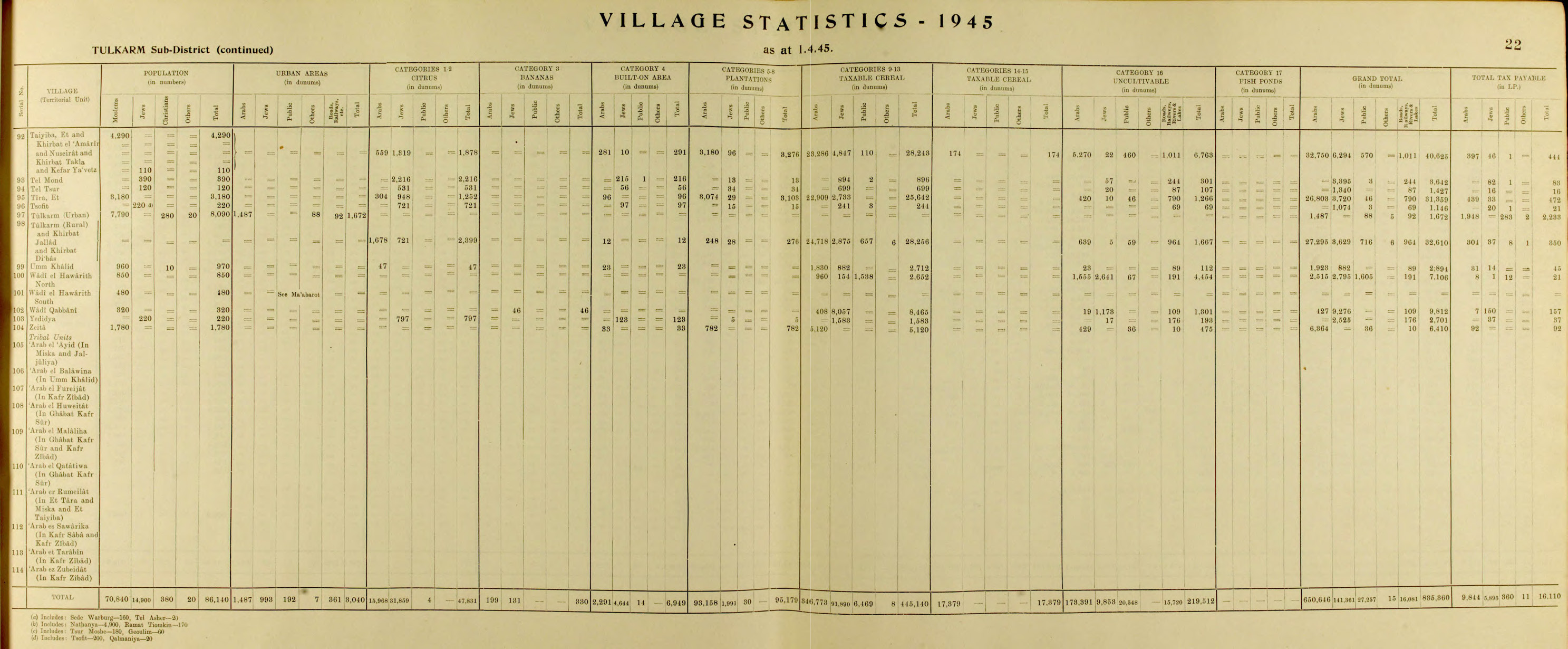
Wadi al-Hawarith
Wadi al-Hawarith
وادي الحوارث | |
|---|---|
Desa | |
 Wadi al-Hawarith | |
| Koordinat: 32°23′56″N 34°52′48″E / 32.39889°N 34.88000°E | |
| Grid Palestina | 139/201 (Utara) 139/200 (Selatan) |
| Entitas geopolitik | Mandat Palestina |
| Subdistrik | Tulkarm |
| Tanggal pengosongan | 15 Maret 1948[2] |
| Luas | |
| • Total | 7,106 dunams (7,106 km2 or 2,744 sq mi) |
| Populasi (1945) | |
| • Total | 1,330[1] |
| Sebab pengosongan | Serangan militer oleh pasukan Yishuv |
| Sebab sekunder | Kekhawatiran akan ditangkap dalam pertikaian |
| Wilayah saat ini | Kfar Haroeh,[3] Geulei Teiman[3] |
Wadi al-Hawarith (bahasa Arab: وادي الحوارث) adalah sebuah desa Arab Palestina di Subdistrik Tulkarm. Desa tersebut dikosongkan saat Perang Arab-Israel 1948 pada 15 Maret 1948, usai Perang Saudara Mandat Palestina 1947–48.[2] Desa tersebut berjarak 16.5 km dari barat laut Tulkarm.
Referensi
Daftar pustaka
- Adler (Cohen), Raya (1988). "The tenants of Wadi Hawarith: Another view of the land question in Palestine". International Journal of Middle East Studies. 20: 197–220. JSTOR 162960.
- Barron, J. B., ed. (1923). Palestine: Report and General Abstracts of the Census of 1922. Government of Palestine.
- Bracy, R. Michael (2010). Printing Class: 'Isa al-'Isa, Filastin, and the Textual Construction of National Identity, 1911-1931. University Press of America. ISBN 0761853774. (p. 99 ff)
- Department of Statistics (1945). Village Statistics, April, 1945. Government of Palestine.
- Hadawi, S. (1970). Village Statistics of 1945: A Classification of Land and Area ownership in Palestine. Palestine Liberation Organization Research Center.
- Khalidi, W. (1992). All That Remains: The Palestinian Villages Occupied and Depopulated by Israel in 1948. Washington D.C.: Institute for Palestine Studies. ISBN 0-88728-224-5.
- Mills, E., ed. (1932). Census of Palestine 1931. Population of Villages, Towns and Administrative Areas. Jerusalem: Government of Palestine.
- Morris, B. (2004). The Birth of the Palestinian Refugee Problem Revisited. Cambridge University Press. ISBN 978-0-521-00967-6.
- Oppenheim, M. Freiherr von (1943). "Die Beduinen. Die Beduinenstamme in Palastina, Transjordanien, Sinai. Hedjaz". International Journal of Middle East Studies. 2. Leipzig: 51–55.
Pranala luar
- Welcome To Wadi al-Hawarith, Palestine Remembered
- Wadi al-Hawarith, Zochrot
- Survey of Western Palestine, Map 10: IAA, Wikimedia commons